
Monitoring to Better Protect
What is an ecological sustainability monitoring program?

This program, coordinated by Parks Canada, is designed to measure progress in achieving conservation objectives and to guide and support the evaluation of the protection measures put in place. It oversees the collection and analysis of a wide range of data to assess the state of and changes in the park’s ecosystems, the factors putting pressure on these ecosystems and the human activities taking place there.
The Marine Park’s conservation objectives include managing marine activities sustainably, and protecting the diversity of species, habitats, and ecological processes,
including their capacity to adapt to climate change.
The assessment of the state of the Marine Park in terms of ecological sustainability is based on indicators divided into three themes.
Environmental Quality
Toxic Algae Monitoring
Objective:
• Monitor the presence and concentrations of toxic algae.
In collaboration with: DFO
Since: 1994
Methodology: Water and phytoplankton samples are collected at the Tadoussac marina, then analyzed in the laboratory (photo 1). These samples are part of a larger sampling protocol managed by DFO and carried out at various locations in the Estuary and Gulf of St. Lawrence.
Results: Water quality indexes between 2016 and 2020 are the best since 1994. Toxic algae blooms were few and far between for this period. In previous years, this index has varied considerably, with a minimum reached in 2008. In 2008, a major red tide–the result of record concentrations of Alexandrium catenalla–killed thousands of mollusks, birds, fish, and marine mammals, including the beluga whale.
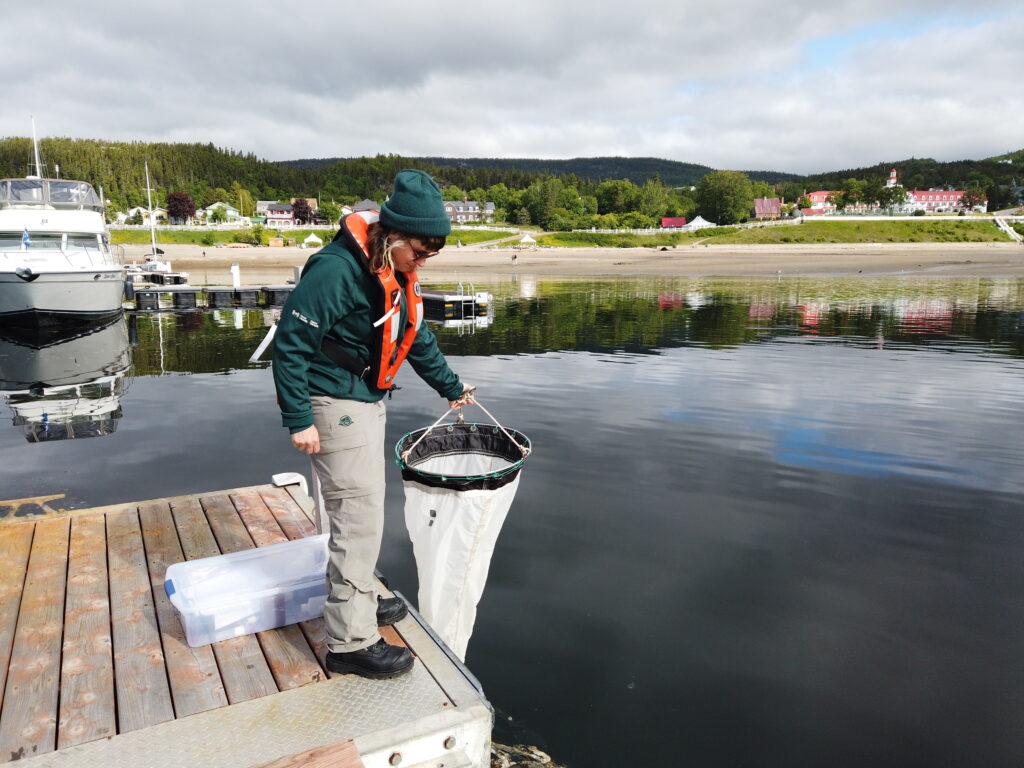
Photo 1: Phytoplankton is collected using a net at the Tadoussac Marina.
Physicochemical Water Condition Monitoring
Objective:
• Monitors changes in water column temperature in various sectors and oxygen concentrations in the deep-water layer of the Lower Estuary.
In collaboration with: DFO
Since: 2009
Methodology: Data on temperature, salinity and oxygen concentration is collected at various depths using CTD equipment (photo 2). A DFO oceanographic buoy off Rimouski has also been continuously collecting this type of data since the early 1990s.
Results:
n recent years, surface water temperatures have been relatively stable on average with interannual variability. However, the trend is increasing over the long term. Deep water temperatures are rising steadily, reaching record highs in recent years.
Dissolved oxygen concentration levels in the deep layer of the Lower Estuary are getting lower and lower. The lowest concentration rate was recorded in 2020, with an average value of less than 15%, far from the minimum oxygen threshold (hypoxia) set at 20%.

Photo 2: A CTD is deployed from the research vessel L’Alliance. It measures the concentration of oxygen in the water column, temperature, and the depth at which the measurements are taken.
Aquatic Invasive Species Monitoring
Objectives:
• Detect the presence of aquatic invasive species
In collaboration with: DFO
Depuis : 2017
Methodology: Aquatic species collectors are installed in marinas and wharfs located on the Saguenay Fjord and the Lower Estuary of the St. Lawrence River (photo 7). Samples are sorted to detect the presence of invasive species.
Since 2021, environmental DNA has also been used to detect aquatic invasive species. This method involves collecting and analyzing water samples to detect the genetic material of non-native species
Results: No invasive aquatic species have yet been detected in the Marine Park. Nevertheless, it is essential to continue this monitoring, as climate change and an increase in shipping activities create favourable conditions for their establishment.

Photo 7: Collectors gather potentially invasive aquatic species.
Marine Soundscape Monitoring
Objectives:
• Create a portrait of the marine acoustic environment;
• understand the impact of underwater noise on species;
• characterize the effect of speed reduction measures on ambient noise and marine mammals.
In collaboration with: UQAR, UQO
Since: 2022
Methodology: One hydrophone is located in the Upper Estuary off Charlevoix, and a second in the Lower Estuary near Les Escoumins. This equipment records sounds continuously (photo 3).
Results: The project began in 2022, with the objective of using the data collected to establish indicators for the Marine Park’s underwater soundscape. This will allow us to assess the tranquillity of each sector over time, characterize shipping noise and the rate of detection for various species detected by the hydrophones.
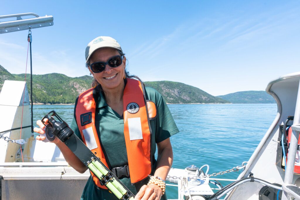
Photo 3: Hydrophones are immersed into the water and used to record the sounds of marine organisms and human activities.
Contaminant Monitoring
Objectives:
• Characterize sediment contamination in the critical habitat of the St. Lawrence Estuary beluga whale;
• assess and monitor the health of coastal ecosystems using the soft-shell clam as a bio-indicator.
In collaboration with: ECCC (soft-shell clam), DFO (sediment)
Depuis : 2016 (soft-shell clam), 2020 (sediment)
Soft-shell clam
Methodology: Soft-shell clams are collected in four areas of the Marine Park, two of which are close to urban areas (photos 4 a and b). Data analysis is carried out in the laboratory by our partners.
Results: Soft-shell clam samples from sites close to urban areas are more contaminated than those from the two more natural areas. The analysis identifies combustion products such as gasoline and diesel as potential sources of pollution.


Photos 4 a and b: Soft-shell clams are harvested by digging with a shovel. The clams are then measured and sent to our partner for analysis.
Sediment
Methodology: Sediment samples are taken at several locations in the beluga’s critical habitat using a grab sampler (photos 5 and 6).
Results: The sediment samples are currently being analyzed.


Photo 5 and 6: From L’Alliance, a grab sampler is lowered to the seafloor. When it hits the bottom, it closes and collects a sediment sample.
Habitats and Species
Coastal Habitat Monitoring
Objectives:
• Delineate and characterize herbaceous areas in various coastal sectors of the Marine Park;
• measure changes in their composition over time.
Depuis : 2022
Methodology: Delineations are made using images captured with a drone (photo 8). The plant species identified are then confirmed with on-site visits.
Results: The first year of monitoring enabled us to refine the protocol by defining target species, acquiring specialized remote sensing equipment and testing a variety of methodologies. Over the coming years, the data will be used to assess the state of the coastal environment, an essential breeding and feeding habitat for many aquatic species.

Photo 8: An orthoimage is a mosaic of georeferenced photos taken by a drone. Aerial images are used to measure the surface area of the grass beds studied.
Pelagic Prey and Predator monitoring
Objective:
• Establish a portrait of the distribution and abundance of marine mammals and birds and their prey.
Since: 2009
Methodology: Prey tracking is carried out using an echo sounder installed on our research vessel, L’Alliance. The equipment emits soundwaves and measures the echoes produced when the soundwaves are reflected off organisms in the water and on the seabed (diagram 1). Observers simultaneously count predators (marine mammals and seabirds) from the vessel’s top deck (photos 9 and 10).
Results: Preliminary data collected between 2016 and 2020 shows high concentrations of fish, thought mainly to be sand lance. Krill concentrations appear to be lower between 2018 and 2020 than in previous years.


Photos 9 and 10 : While prey data from the echo sounder is being recorded by an on-board computer, team members on the upper deck of L’Alliance record their observations of predators.

Diagram 1 : The data collected by the echo sounder allow us to assess the type, density, distribution, and abundance of prey present. Here, at around 100 m, an aggregation of krill has been detected.
Monitoring Barrow’s Goldeneye in its Winter Habitat
Objective:
• Learn how the Eastern Barrow’s goldeneye population uses the Marine Park.
In collaboration with: Sépaq (2014-2015), OOT (since 2021)
Since: 2014
Methodology: Bird surveys are done from shore (photo 11). This monitoring program initially focused on the Baie-des-Rochers (Saint-Siméon) area of Charlevoix, but now covers 11 bays between Port-au-Persil and Les Escoumins.
Results: Data collected at Baie-des-Rochers between 2014 and 2020 shows a slight decline in use of the area by Barrow’s goldeneye. The 10 additional monitoring sites will give us a better idea of their use of the Marine Park as a whole.

Photo 11 : A member of the OOT team records her observations.
Harbour Seal Monitoring
Objectives:
• Know the number and ratio of seal pups and adults;
• know how the main haul-out sites are used.
In collaboration with: Sépaq
Since: 2007
Methodology: The Parks Canada and Sépaq teams simultaneously travel along the Saguenay Fjord, counting harbour seals at haul-out sites and in the water (photos 12 and 13).
Results: Use of the main haul-out sites in the Saguenay Fjord by harbour seals is stable.
AVERAGE PRESENCE OF HARBOR SEALS IN THE FJORD
| Between 2007 and 2015 | 45 |
| Between 2016 and 2020 | 69 |


Photo 12: A Sépaq employee monitoring harbour seals. This team starts its inventory from Baie-Éternité, while the Parks Canada team heads upstream from the mouth of the fjord.
Photo 13: Harbour seals gather, rest and moult at haul-out sites.
Visual and Photographic Census of Large Whales
Objective:
• Acquire knowledge on the abundance, composition, and residence time of large whales in the Marine Park.
In collaboration with: GREMM
Since: 1985 (GREMM), 2006 (PC)
Methodology: REMM has been monitoring the population since 1985, using photo-identification to estimate abundance and track changes in the number of individuals within the same season and from year to year (photos 14 and 15).
An analysis of historical photo-identification data (1990-2020) was undertaken with the GREMM as part of Parks Canada’s Sharing the Waters with Belugas project, ongoing since 2017
Results:
NUMBER OF INDIVIDUALS PHOTO-IDENTIFIED ANNUALLY
BETWEEN 2016 AND 2020
| Species | Min – max | Average |
| Blue Whale | 1 – 9 | 5 |
| Fin Whale | 12 – 40 | 24 |
| Humpback Whale | 2 – 28 | 14 |

Photo 14: Photo-identification enables individuals to be identified by their distinctive colour patterns, dorsal fin shapes or markings.

Photo 15: The GREMM team in action.
Marine use
Ice Fishing Monitoring
Objective:
• Monitor the status of groundfish populations caught in the Saguenay Fjord.
In collaboration with: DFO, Sépaq
Since: 1995
Methodology: With both visits to ice fishing sites and the cooperation of fisherman we are able to collect data such as the number, size and weight of fish caught, as well as the number of fishermen and fishing hours (photo 16). Sites within the Marine Park include Sainte-Rose-du-Nord, Saint-Félix-d’Otis, Rivière-Éternité and L’Anse-Saint-Jean. DFO oversees this monitoring and uses the data gathered to adjust management measures for this type of fishing.
Results: The main groundfish species caught are redfish, Atlantic cod, Greenland cod and Greenland halibut. Since 2016, there has been an increase in the number of redfish caught measuring less than 23 cm. These smaller redfish are the result of a new cohort, born in the years 2011, 2012 and 2013, entering the Saguenay Fjord. The abundance of redfish in the Estuary and the Gulf of the St. Lawrence is on a scale not seen in 30 years.

Photo 16: The team goes directly to ice fishing sites to measure the specimens.
Monitor Shipping and Navigation Activities with AIS data
Objectives:
• Characterize the intensity, sectors and seeds of navigation in the Marine Park;
• assess compliance with protection measures designed to minimize underwater noise and the risk of collision with marine mammals.
In collaboration with: CCG
Since: 2012
Methodology: The Automatic Identification System (AIS) is a continuous and automated system used to exchange messages between ships and land stations via VHF radio. Approximately every minute, the geographical position, speed, and identification of AIS-equipped boats navigating in the Marine Park are archived (graph 2).

Graph 2 : Each point is an AIS transmission from a whale-watching boat, enabling it to be identified and its speed to be determined. The white dots are from when the boat was in transit; the red dots are while it was observing marine mammals.
MERCHANT MARINE AND INTERNATIONAL CRUISES
Voluntary slowdown measures in whale feeding areas
Objective:
• Reduce the risk of collision with baleen whales during the period when they are most present in the Lower Estuary.
In collaboration with: G2T3M
Since: 2013
Methodology: The 10-knot slowdown area in the Lower Estuary is a voluntary measure in place from May 1 to October 31 in the Saguenay–St. Lawrence Marine Park (Map 2).
Results: The industry’s commitment to the measure has led to a significant reduction in the average speed of transits when the measure is in effect. In 2022, over 98% of passages were made at or below normal ship speed (14 knots).
Avoiding the channel south of Île Rouge
Objectives:
• Minimize the impact of noise and disturbance to belugas;
• avoid increasing transits to the south of Île Rouge.
In collaboration with: G2T3M
Since: 2014
Methodology: From May to October, merchant ships and international cruises are invited to use the Laurentian Channel on the north shore of the estuary rather than the channel south of Île Rouge (map 2).
Results: Adherence to this measure has made it possible to maintain traffic volume to the south of Île Rouge at around 5% of transits between 2014 and 2020.
Whale Watching Activities
Speed reduction area at the mouth of the Saguenay Fjord
Objective:
• Measure and improve MAR compliance
Since: 2018
Methodology: Every week since 2021, companies have received a report that summarizes the AIS data emitted from their boats. This report, put in place trough consultations with whale watching compagnies, serves as a self-assessment tool for compliance with the slowdown measure at the mouth of the Saguenay Fjord and the St. Lawrence Estuary.
Results: Between 2018 and 2020, 27% of tour boats complied with the new speed limit at the mouth of the Saguenay Fjord or confluence, which was introduced in 2017. This percentage increased to around 75% in 2021 and 93% in 2022, reducing disturbances, the risk of collisions and underwater noise.
Upper Estuary Conservation Area
Objectives:
• Monitor compliance with the regulations prohibiting whale watching activities in the Upper Estuary conservation area (Map 2);
• minimize disturbance and noise in this portion of the beluga’s critical habitat, which is heavily used by females, juveniles, and calves.
Since: 2019
Methodology: An automated AIS alert system was introduced in 2022. It sends out an alert as soon as a whale watching boat enters the area.
Results: In 2022, 99.87% of whale watching excursions complied with the measure. The presence of park wardens on the water and automated alerts has allowed for more rapid interventions.
Whale Watching Activities Monitoring
Objectives:
•
Measure concentrations of marine mammals and boats at observation sites;
• monitor target species and the sectors visited during whale watching activities.
In collaboration with: GREMM, MMON
Since: 1994 (PC-GREMM), 2014 (MMON)
Methodology: Every 10 minutes, observers aboard tour boats from different companies records the boat’s position and activity, as well as the number of boats and marine mammals within a 2-km radius.
Results: In total, approximately 3,000 excursions have been sampled since 1994. The data shows that the species targeted during excursions fluctuates over time (graph 1). This monitoring contributed to the creation of measures included in the MAR in 2002 and its revision in 2017.

Graph 1 : This graph shows the variation in species targeted each year during whale watching excursions from Tadoussac.
Monitoring Marine Mammals and Marine Traffic Activities from Land-based Stations
Objectives:
• Characterize the use of key areas of the Marine Park and beluga whale critical habitat by marine mammals and marine traffic from different land-based observation points;
• characterize cohabitation between whales and boats and assess the effectiveness of management measures put in place to enhance marine mammal protection.
Methodology: Every 10 minutes, observers visually scan one of the defined sites along the shores of the St. Lawrence Estuary and Saguenay Fjord (map 1). They record information about marine mammals (number, distance, presence of young, behaviour) and boats present (type, activity, location).

Map 1 : Network of land-based observation sites used to monitor marine mammals and marine traffic activities.
SAINTE-MARGUERITE BAY
Objectives:
• Characterize the beluga’s use of this key area;
• assess compliance with measures implemented to enhance their protection.
In collaboration with: Sépaq
Since: 2003
Results: Between 2003 and 2016, 86% of beluga whale groups observed in the study area were located inside the bay. The majority were groups of adults accompanied by juveniles and newborns. Analysis of the data collected led to the creation of an area temporarily closed to navigation.
Area Closed to Navigation
Objective:
• Enhance beluga protection in St. Marguerite Bay by reducing disturbance from marine traffic activities
Methodology: Since 2018, the area closed to navigation, in effect from June 21 to September 21, extends from Cape Nord Ouest to Cape Ste. Marguerite, all the way into the bay (map 2).
Results: Compliance with this measure is quantified during land-based monitoring. Prior to the closure, pleasure boats were present in the bay for about 25% of the observation time. Since the closure, this time is less than 5%. This translates to an increase in tranquility for belugas who use the bay.
MOUTH OF THE SAGUENAY FJORD
Objectives:
• Characterize the beluga’s use of this key area;
• assess compliance with measures implemented to enhance their protection.
Since: 1998
Results: From 2003 to 2016, 76% of observations made between July and August from the Pointe-Noire Interpretation and Observation Centre reported the simultaneous presence of belugas and boats. These findings led to the modification of certain measures in the MAR, including a speed limit in this sector from May 1 to October 31 to reduce the risk of collision, disturbance, and underwater noise (map 2).
MARINE ESTUARY (MARINE ENVIRONMENT DISCOVERY CENTRE)
Objective:
• Characterize the use of this area by species at risk (beluga, blue whale) and by marine traffic activities.
Since: 2020
Results: An analysis of the observation data has allowed us to obtain a portrait of the use of this area by marine mammals and marine traffic. It demonstrates the need for a stronger patrol presence to ensure compliance with the MAR.
SOUTH SHORE (CACOUNA AND RIVIÈRE-DU-LOUP SECTORS)
Objective:
• Characterize the use of this area, located outside the boundaries of the Marine Park, by beluga whales and marine traffic activities.
In collaboration with: MMON
Since: 2014
Results: The Cacouna region has been identified as a prime area on the south shore for studying beluga behaviour. There is less shipping activity than in other areas, making it a quieter place for herds of females accompanied by juveniles and newborns. Data from Rivière-du-Loup confirms the importance of this area for beluga feeding.

Map 2 : Measures put in place to enhance marine mammal protection in the Marine Park, based on monitoring carried out by Parks Canada and its collaborators.
To better protect, we need to know.
For this reason, day after day, we must deepen our knowledge. Parks Canada’s ecological sustainability monitoring program, run by a passionate team and numerous collaborators, plays a key role, as do the many research projects currently underway.
It is essential to understand how the Marine Park’s exceptional biodiversity and its three major ecosystems evolve, react and adapt to different threats, so that we can implement effective management measures to protect this exceptional territory.